
The Preserve & Trails
open to the public for hiking, skiing, snowshoeing, berry-picking....
The Madeline Island Wilderness Preserve's mission is the protection and preservation of natural areas on Madeline Island for everyone's enjoyment. "Natural Areas" include both the plants and animals in these areas. While MIWP lands are open to the public, they are private properties and subject to rules to protect their natural features.
Deer hunting is permitted during the State of Wisconsin's hunting season.
Hunting, trapping, or snaring all other animals, including bears, coyotes and wolves, is prohibited.
Biking on MIWP trails is prohibited.
Motorized vehicles are not allowed in Preserve lands.
Camping and fires are not allowed in Preserve lands.

Madeline Island Wilderness Preserve holds over 2900 acres of land on the island. The largest parcels are at the South end of the island, close to town, and at the far North end of the island, where the very first land in the preserve is located. Our focus is to preserve lands in the interior of the island contiguous to other preserved land.
These lands have minimal improvements, which make them accessible to hikers, berry-pickers, nature enthusiasts, and cross-country skiers and snowshoers.
The trails in the North section are more primitive, while the South end trails have been leveled and widened to make them accessible to day-hikers and novice cross-country skiers and snowshoers.
Note: The trails have been mapped by hikers using the AllTrails app — if you want to use these GPS maps be sure to download the trails to the app on your device before setting out, since cell service is sketchy on much of the island — especially the north end.
Madeline Island Ski & Hiking Trail—South Section

Capser Trail
The Capser Trail, which is within walking distance from the ferry landing, begins at a parking area in 28 acre Forest Park, which is owned by the Town of La Pointe. The entrance is on the south side of County H (Big Bay Road) across from the Fire Hall. The trail continues through land owned by Madeline Island Wilderness Preserve and ends at a parking area on Middle Road. This handicap accessible trail is a multi-use trail designed for recreation and education, and is used by students from the La Pointe School, as well as by year-round and summer residents and visitors to the island. Students from the La Pointe School have added a “Little Village” of miniature buildings close to the beginning of the trail. The trail is approximately 2 miles long, round-trip, and is a well-maintained, easy hiking trail. Insect repellent is advised in season. This trail is also an easy cross-country trail in winter. Snowshoers, please keep to the side of the path groomed for cross-country skiers. The trail is named for Leo and Bella Capser, who made preservation of the island's story their personal mission, and were instrumental in founding the Madeline Island Museum.
Nucy Meech Trail
The Nucy Meech Trail is a loop off of the Capser Trail. This portion of the trail is .85 miles long, and serves as a good trail for hiking and snowshoeing. It also provides a means of monitoring the spread of invasive species such as buckthorn and barberry. The trail is named in honor of Nucy Meech, one of the founding board members of Madeline Island Wilderness Preserve.
Madeline Island Ski & Hiking Trail—North Section
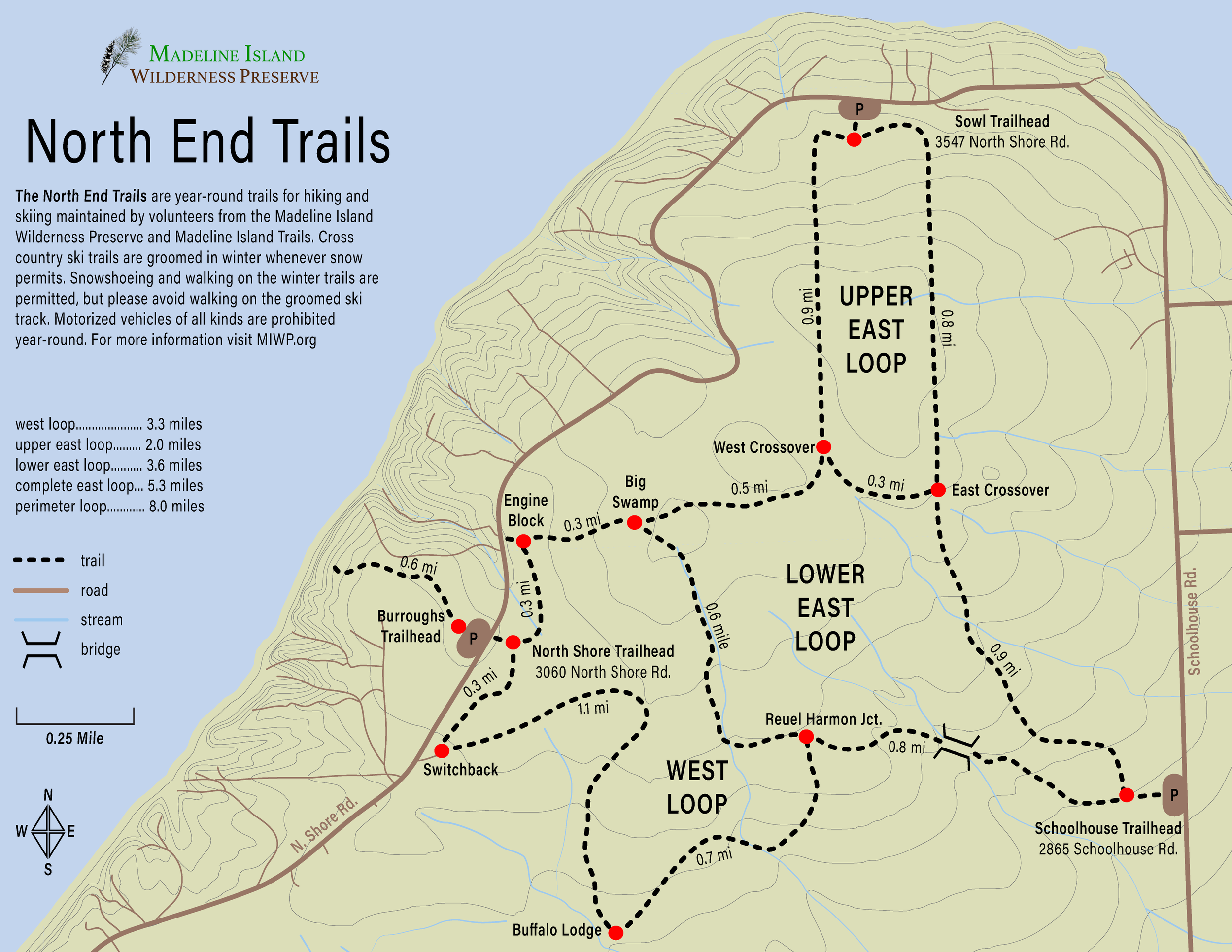
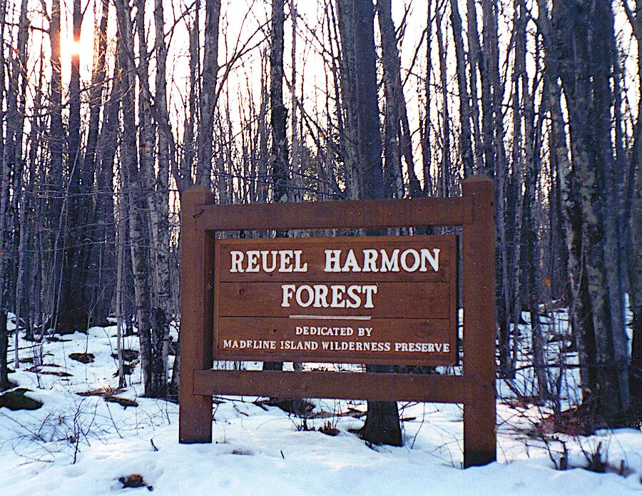
At the north end of Madeline Island, stretching between School House Road and North Shore Road, is the largest contiguous tract of land in the Wilderness Preserve. The Reuel Harmon Forest is named to honor the man whose generosity and foresight allowed us to buy the land when such large tracts of the Island were still in single ownership and reasonably affordable. Well in excess of 1000 acres, the forest’s well-drained soils are beautifully cloaked with a mixture of northern hardwoods—sugar maple, yellow birch, red oak, paper birch, and aspen—plus scattered hemlock and the occasional white pine. Some of these trees, especially those growing in the little valleys cut by intermittent streams, are ancient gnarled giants, but most are lanky and young (as trees go), owing their origins to the slash fire that roared across the Island in the fall of 1910.
The North End Trails, which are east of North Shore Road and west of Schoolhouse Road, have been reclaimed from old survey lines and logging roads. Cross country skiers, snowshoers, hunters, hikers, blueberry pickers and nature enthusiasts enjoy these trails, which consist of two different loops that range from 3 ¾ miles to 7 miles long. The trails are marked with colored tree blazes to help guide hikers and skiers.
In spring, summer and fall, these trails can be wet, and the terrain is uneven and sometimes boggy. Hikers are advised to wear appropriate footwear and protective clothing, and perhaps bring a walking stick. Insect repellent is also advisable. Hikers should know how to follow trail markings and be comfortable hiking primitive trails. (Cell phone service is sketchy, or non-existent, on this end of the island. If you are using a GPS trail app like AllTrails, be sure to download the trail maps to your phone before setting out!)
The small loop is best traversed from the Burroughs Trailhead, on the east side of North Shore Road. The trail is for the most part on gently-sloped land that holds many wet spots, winding its way through a forest of second growth maple, oak, yellow birch, birch, and poplar, with small stands of hemlocks and cedars. This is the easier trail for cross-country skiers. Snowshoers, please keep to the side of the path groomed for cross-country skiers.
The larger loop, accessed from either the Sowl or Reuel Harmon Trailhead, has some steeper slopes (steep for novice cross-country skiers), and the same forest configuration, except there are more hemlocks and pines, especially on the steepest grade of the trail. There is a large cedar/hemlock forest/swamp located between the Sowl Trailhead and Big Swamp trail-sign locations. Novice cross country skiers should ski the long loop in a counterclockwise direction. Snowshoers, please keep to the side of the path groomed for cross-country skiers.
The Burroughs trail to the lake shore is accessed from the Burroughs Trailhead. The trail begins on an 80 acre tract of Wilderness Preserve land, and as it gets closer to the lake, the tract narrows to a 100 foot wide strip ending in an ancient hemlock grove on a high bluff above the lake. Hikers should not attempt the steep banks down to the lake shore, since these ravines are on private property.
Finding the North Section Trailheads
Keep in mind that the following distances are not precise.
The Burroughs/North Shore Trailheads are approximately 2.7 miles NE from the intersection of North Shore Road and Benjamin Boulevard, fire number 3060 North Shore Road. The North Shore Trailhead is directly across the street. Parking is available.
The Sowl Trailhead is approximately 4 miles NE from the intersection of North Shore Road and Benjamin Boulevard, approximately 2 miles further than the Burroughs Trailhead. From the other direction the Sowl Trailhead is approximately 3 miles N from the intersection of Big Bay Road and Schoolhouse Road, and approximately 2.3 miles N of the Reuel Harmon Trailhead. Parking is available.
The Reuel Harmon/Schoolhouse Road Trailhead is approximately .7 miles N from the intersection of Big Bay Road and Schoolhouse Road, approximately 300 feet N of a driveway with fire number 2848 Schoolhouse Road. Parking is available.