
The Perfect Storm
/Adam Haecker, 2015
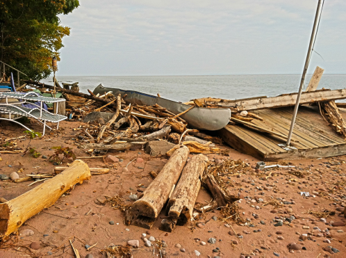
Capser Road beach scene after the storm; photo by Tina Nelson
By Adam Haecker
“IT WAS A DAY REMINISCENT OF THE GALES OF NOVEMBER. THE SKY GREW DARK, THE RAIN INEVITABLY BEGAN TO FALL, AND THE WIND BLEW WITH SUCH FURY THAT MADELINE ISLANDERS BEGAN REALIZING THAT THIS WAS NO GARDEN-VARIETY EVENT FOR EARLY SEPTEMBER. NO, THIS WAS A STORM LIKE NO OTHER – AT LEAST AT THIS POINT ON THE CALENDAR.”
If you were on the island on Sept. 10, 2014, something in the air didn’t feel right. You know that feeling you get before a storm when your conscience oscillates between fascination and fear? And no doubt Gordon Lightfoot played in the heads of those who stood in awe, watching what would remind them of the lake that wouldn’t give up its dead. You remember: that song about the nearly 1,000-footer that sank in the eastern part of Lake Superior so many years ago in 1975?
According to the Duluth office of the National Oceanic and Atmospheric Association (NOAA), the wind at midnight on Sept. 9 was about 6 knots with gusts to about 11 knots. By 10 p.m. on the same day, the wind increased to about 25 knots with gusts to about 33 knots. If it’s hard for you to wrap your mind around all these knots, number one, you’re not alone; but number two, that’s quite an increase for a relatively short amount of time. And although the sustaining wind slowly began to taper during the waking hours on Sept. 10, the gusts remained strong. Needless to say, those empty coffee cups or stray tarps sitting unattended were the least concern. What we have here is a storm of such magnitude that docks and piers felt the brunt, and the perimeter of the island began looking like its own shipwreck by day’s end.
Looking east near the point at the state park.
But this is only one of several ingredients in the mix that day. Add in the rise of water level, and the conditions get all that more interesting. Again, referencing the Duluth office of the NOAA as a resource: At midnight on Sept. 9, the water level was about 602.6 feet. By around 5 a.m. on Sept. 10, the water level peaked at 603.5 feet (nearly a foot difference) before seesawing up and down for the next day or so. To put this in perspective, the water level was so high that it was splashing up from underneath the decking (top planks) of many of the docks and piers around the island. This pressure caused many planks to break loose and float free. It also caused many property owners along the shoreline to break as well…into a cold sweat.
Greg Nelson is a dock builder for C.A. Nelson & Son Dock Construction on the island. He concurs like many others that the day had an eerie feel, and before he knew it, his mettle would be put to the test. “Yeah, the day kind of reminded me of the day that the Edmund Fitzgerald went down,” says Nelson. “The seas just kept building and building throughout the day.”
Nelson has mastered his craft of building docks. He constructs each section (crib) with care, proper reinforcement and the best timber for this trade. He also understands the wrath of Mother Nature, and if she so chooses, your life can be become unhinged – one plank at a time. “I think the day of the storm I received nine or 10 calls from property owners whose docks were coming apart,” he says. “And the calls just kept rolling in after that. In fact, I have so much repair business, that I won’t begin to get caught up until next season.” (That is, the year 2016.)
Nelson states that, as logic would dictate, the older docks were more susceptible and vulnerable to damage, but plenty of newer ones were scathed as well. “The problem was that the water was so high that it was splashing up and through the top decking (planks), and causing a lot of pressure. As a result, those planks were coming loose, and floating down the shoreline. We saw more of this happening with the older docks.” Adding insult to injury, the wind blew just so that really no stretch of shoreline was safe from its onslaught. Nelson thinks that any property immediately north of the town dock was probably the least affected by the storm, but even that can’t be safe to say. Furthermore, the wreckage of planking and other debris pooled on the south end of the island; making it look like a scene from the television series titled ‘Lost.’
Maybe this storm deserves a name. You know, like the severe and potent hurricanes that potentially ravage the southern coast of the United States every year. Regardless, let’s hope that this storm is of the 500-year variety, and so rare, that even deckhands on another freighter 40 years from now will still be humming something about the lake they call Gitche Gumee.
The "jumping rock" at the state park — the water was splashing across the path!